Tour Du Mont Blanc
Date: June 22-July 4 2022
Videos of our hike are posted on our YouTube channel.
The Tour Du Mont Blanc (TMB) is an epic hike.
If you're reading this blog you probably already know that the hike is approximately 180km and takes you around the Mont Blanc Massif - through France, Italy and Switzerland.
You need to book your accommodations on this hike many months in advance. It is a very popular hike. We had everything booked by January 2022, for a late June start. And even booking when we did, we did not get our first choices in accommodations. And that was during Covid when people were travelling less. So be prepared, book well in advance. Next time we do it we will probably aim to have everything booked at least 8 months out.
We decided to try for the very beginning of the hiking season, starting on June 22. In the planning phase, others had written about tackling snow and ice at the start of the hiking season. We did not have that experience. Summer of 2022 was very warm in Europe. By the time we started the hike the snow had all completely melted, the flowers were out in full bloom. The only ice that we experienced was a glacier we crossed early on in the hike. That said, you always should be prepared for any weather when you are hiking in the mountains. Storms can hit suddenly. And temperatures plummet at night.
When it comes to planning, there are different routes you can take along the way. For example, towards the end of the hike we wanted to do the Fenêtre d'Arpette route, whilst the other 3 members of our group wanted to take the 'easier' (though only marginally) and 'safer' route. To be clear, the Fenêtre d'Arpette is not unsafe if the weather is clear, and there is no snow. You also have to be physically prepared for jumping boulder to boulder with your pack. You can check the conditions the morning you plan to hike that section and make your decision then. If the fog is heavy it wouldn't be worth it to exert yourself that much and not get the view.
Your route can also be affected by the available accommodation. And there are options along the way to make the hike easier or harder according to your preference. We were a group of 5 hikers, two couples and a single woman - we are all between 35-45 years old. We all took different routes and met back up. One couple did the first 3 days of hiking, then took a bus and train to get to Courmayeur and continued the hike from there. While the other three of us continued together until Refugio Elisabetta. Then early the next morning we parted ways, we opted for the long route, but our friend split and took the bus (just a short walk downhill from the refuge) into Courmayeur to meet up with the other couple. They continued the hike from there, up to our next refuge - Bertone. And that's where we met up with them.
When researching for this trip there was not enough information about the food options along the route. We were coming to TMB from Canada, and we were nervous about what we would be packing for food. We do a lot of hiking here in Canada and usually we make our own dehydrated meals. It's a fraction of the cost of store-bought meals, fresher and no preservatives. Plus your options are only limited by your imagination. However, you cannot bring meat or dairy into Europe. From all the research we did, we figured that includes dry food. So we decided to make vegan meals. This was totally unnecessary though, since you can get food for breakfast and dinner wherever you choose to stay - even if you are free camping in France. When you have delicious, fresh European food close by, no one wants to reach for the dry camp food. No one. We ended up throwing out a bunch of the meals we had brought. The food you can get on TMB is fresh and affordable. And just so much better than dehydrated camp food.
Our advice is to budget for fresh meals. If you're crazy tight on cash, then of course do camp food. Just know that there are options. And you WILL want them. Plus not carrying your meals means less weight in your pack.
For lunches you can either pick up a packed lunch from your refuge - many offer a packed lunch. Or there are stores where you can get bread and meat and cheese. We had brought sachets of tuna (not cans) and had them on tortillas. The tuna was ok to bring into Europe. And of course, when you're hiking you need some kind of nut/seed snack for energy. We would recommend packing for just a few days (to reduce the weight you are carrying). You can restock in Chamonix or Courmayeur, and probably many other places in between.
The night before starting the hike we stayed in Chamonix. There is more happening in Chamonix than in Les Houches. But our friends stayed in Les Houches. We got a ride from Chamonix to Les Houches where we met up with them to begin the hike. You can walk the distance between the two - It would add approx 7km, but with not much benefit (i.e. not much to see).
DAY 1 - Les Houches to Miage
We started our hike on June 22, 2022 - which is very early in the season.
The day started a little rainy, but it soon cleared up. To cut out a big hike up with little views, we opted to take the cable car from Les Houches to Bellevue. It is €17.50 per person one way, and with the massive hike ahead of us was worth every euro.
There is plenty of signage along the way, so you won't get lost.
Our original plan had been to end our first day in Les Contamines, but we opted for Miage instead. And we are so glad that we did. The descent from Col de Tricot to Refugio de Miage is huge. We could have made it the extra distance to Les Contamines, but it would have been a push.
We strongly recommend knee support and hiking poles. We have done many hikes without, but since buying them it's hard to imagine how we ever did. And for the TMB you are going to want hiking poles.
 |
| Descent into Miage |
As of 2022 you can free camp in France, so that is what we did. There was some beautiful camping spots at Miage, but aim to stay on higher ground if possible. We had a storm hit that night and our friends tent got a little flooded. They had to move during the night, which is no fun - trust me. There were plenty of camping spots available here the night we stayed. There is a proper toilet available too. And you can get food and delicious pie at the refuge (even if you are not staying in the refuge).
Day 2 - Miage to Refuge de la Balme
Our journey took us through Les Contamines, where we were able to get some fresh fruit at a grocery store, as well as some well deserved, yummy ice creams.
We got rained on, again. There was hail also. Not massive hail, but enough to know it was there. Tip: if you see dark clouds and sense rain is coming, put your rain gear on immediately. For some reason we waited until it was actually raining, and we got drenched. If possible, try for waterproof pants (Arcteryx have some great options). Those of us without waterproof pants had to stop and empty the water that was collecting inside our waterproof shoes. Many of the blogs that we read before doing the TMB said to bring 3 sets of clothes, including socks. After our experience we would say bring 4 pairs of socks, and if your weight/space allows for it, another set of clothes would be handy too.
 |
| Chalets du Truc |
Again, we were in France so we did the free camping option rather than staying in a refuge. The camping area next to the Refuge de la Balme was much smaller than Miage. We recommend arriving early enough to ensure you get a spot.
 |
| Refuge de la Balme - Campground in the background to the left |
 |
| Walking between the Refuge and the Campsite |
The refuge offers food and drink even if you aren't staying as a guest. However, you cannot be in the dining room when they are serving to their guests. The let us sit in there afterwards though, and use the wifi, which was awesome. They also had a washroom that campers could use. But with many users it can get a bit stinky...go early if you can lol
Day 3 - La Balme to Les Chapieux
June 24, 2022
Watch day 3 here.
Our devices died so we don't have exact stats for this day. But we made it!
Two of our group turned back at this point, and went to Courmayeur for a couple rest days. They did not come with us to Les Chapieux.
 |
| Leaving Refuge de la Balme |
We woke up to fog, which was pretty heavy in some areas. It made for a dramatic crossing of an icefield. It was the only ice we encountered on the TMB (other than the hail during a couple of storms...)
 |
| Ice field crossing |
 |
| Ascent towards Col de la Croix |
As we reached the pass it started to rain... then pour... then hail...
Despite our rain gear we were soaked and freezing. When we saw a refuge we couldn’t have been happier. We were able to go inside and dry our shoes and socks by the fire. Meanwhile we had a plate of sausage and cheeses and a glass of wine. Followed up with a slice of delicious pie and a brownie. Just what our souls needed.
 |
| Refuge du Col de la Croix |
 |
| Refuge du Col de la Croix |
Eventually the storm passed and the rain slowed down, so we grabbed our packs and started the descent down to Les Chapieux. The rugged green hills looked like a scene from Scotland (not that we’ve ever been). Stunningly beautiful and different from any of the other vistas on the TMB.
Day 4 - Les Chapieux to Rifugio Elisabetta Soldini (France into Italy)
Day 5 - Refugio Elisabetta to Rifugio Bertone via Courmayeur
Watch day 5 here.
 |
| Approaching Checrouit Ski Resort - Courmayeur in the valley below |
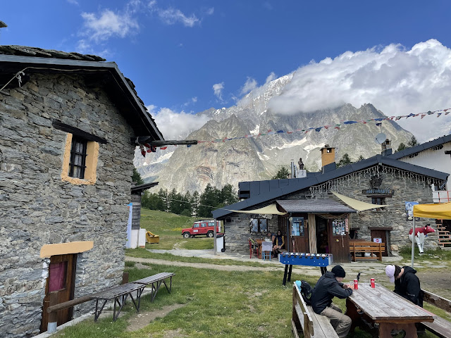 |
| Checrouit Ski Resort |
Day 6 - Refugio Bertone to Val Ferret
 |
| Leaving the refuge |
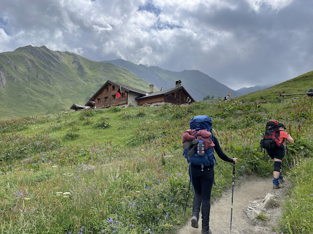 |
| Rifugio Alpino Walter Bonatti |
 |
| The food at Bonatti was phenomenal and the staff were so friendly!! |
 |
| Dean and Jon checking out the ruins |
Day 7 - Val Ferret to La Fouly
Watch day 7 here.
 |
| Chalet Val Ferret |
Time: 6h 43m
The hike from Val Ferret to Grand Col Ferret was gorgeous. A little challenging, since it was a 750m ascent. And it felt like it was straight up.
 |
| View back down to Val Ferret |
 |
| Approaching Grand Col Ferret |
 |
| Grand Col Ferret |
At this pass we crossed from Italy into Switzerland.
Here we were once again hit with a storm. It was so intense, the lightning and thunder were almost simultaneous. And the thunder was so loud. It was a really cool experience. Of course, it can be dangerous so we were hightailing it down from the pass.
 |
| Great views despite the rain |
On the descent there is the Refuge La Peule... where we were able to get a short respite from the rain, and get ourselves a yummy snack and warm up inside. The refuge was absolutely packed with drenched hikers. It was fun to hear everyone's stories and experiences.
 |
| Refuge La Peule |
 |
| Refuge La Peule |
When we headed out from the refuge it was still pouring rain with no glimmer of hope that it might stop. But we had to get to where we were going. We were aiming for a campground in La Fouly, which was still quite a ways.
 |
| Crossing a landslide at Torrent Des Ars |
It rained relentlessly that afternoon. Even when we reached la Fouly it was pouring rain. We couldn't think of anything worse than having to set up a tent in the rain, while we were soaked through... we searched for a hotel, refuge or airbnb that we could stay at instead - but there was literally nothing available. It is a very small town and not many options. But we did find a hotel room in the town of Orsieres, which was only a short bus ride from La Fouly. It meant missing one day of the hike - but apparently this is a "boring" section of the hike. We didn't do it, so we really can't say. But other people have written that it's a flat section where you're mostly in the forest - so no awesome mountain views. It was a hard decision to make, but the rain forced our hand.
REST DAYS
Orsieres and Champex-Lac are beautiful areas with so much to see and explore. We hiked around the lake on our day off and took the chairlift up to La Breya and did a short hike there too.
 |
| A stream near Champex-Lac |
 |
| La Breya chairlift |
 |
| Our airbnb is in the small cluster of homes on the hill to the left |
Day 8 - Orsieres to Le Peuty
Time: 7h 52mDistance: 16.08km
Elevation Gain: 1051m
Elevation: 2669m Max 1337m Min
July 1, 2022
Watch here.

After a well deserved rest, we were ready to continue on with our adventure. In hindsight we probably could have used the rest more around Courmayeur or Val Ferret. Courmayeur is the popular choice (and we can see why). But we were also very happy with our choice.
We took the bus up to Champex-Lac from our airbnb, and from there split up. The three other members of our group were taking the typical TMB route, while we took the slightly more difficult Fenêtre D'Arpette. We've mentioned a couple times in our blog that this variant can be difficult and is not recommended if the weather is bad, or if there is still snow cover. We were very fortunate that we had warm weather leading up to our visit, and the weather that day was pretty decent. We did have a lot of fog, but thankfully no rain. And for a brief moment at the pass the clouds and fog cleared and we got the most epic view.
Here are some view from the two variants:
TMB Route:

Forest climbs

Jon lamenting the view that should have been...

Nearing Le Peuty - our destination for the night

A view from the bridge
Fenêtre D'Arpette:

Big boulders

Rocky climbs

The fog lifting for some dramatic views

Descent towards Le Peuty
In the final stretch before reaching the campsite Kay rolled her ankle. It wasn't too bad.. just bad enough to be annoying.
When we reached Le Peuty it was almost sunset and our friends were getting worried about us. Thankfully we arrived with enough light to get our tent and sleeping pads all set up. A ranger came around for us to pay for our campsite. It was very straightforward, and great that we didn't have to go searching to figure out how to pay. We got a little tag for our tent so he didn't have to come and check us again.
After a quick bite to eat we went and found the most amazing hot chocolates of our lives... they may have been spiked ;-)

Happy Campers

We were treated to an amazing sunset
Exhausted from another epic day of adventure we settled in for the night to rest up for....
Day 9 - Le Peuty to Trélechamps
Time: 8h 18m
Distance 15.71km
Elevation Gain 936m
Elevation 2206m Max 1251m Min
July 2, 2022
Watch here.
...THE GRAND FINALE!
This section of the hike has the most epic views of Mont Blanc. And we had the most crisp sunny day. It couldn't have been more perfect.
To start the day is an ascent through the forest. Every so often there are clearings were you get nice views back to Le Peuty or of surrounding valleys/ridges.
At the Col du Balme we passed from Switzerland back into France. From here it was nothing but awe-inspiring, breathtaking views.

View from Col du Balme
You can stop at the refuge du Col du Balme for a delicious lunch, refreshing drink and possibly the best refuge view of the hike.


We just couldn't get enough!!
That night we camped in Tré-le-Champ. There is a small area next to the refuge La Boerne where you can camp for free.

We recommend arriving early to ensure you get a spot.
There are indoor toilets and showers that the campers can use (separate from the refuge guests). It was a very long wait in the morning to use the toilet.
As with all the refuges we visited along the way, you can purchase food and drinks.

Day 10 - Trélechamps to Chamonix
July 3, 2022
Our last day! We took our time getting ready in the morning, packing up and having breakfast.
It was going to be a short walk today... but it ended up being shorter than we had planned.
Since Kay had rolled her ankle 2 days prior, and then hiked on it for almost 16km, she wasn't feeling able to complete the hike. We decided to stick together as a group - so we all walked together to the train station in Montroc-le-Planet and this is where we finished the TMB.
Hopefully we get a chance to do this hike again. And complete the full circuit.
We think that next time we will plan to stay at refuges the whole way, and not bring our tent at all. We also will be able to plan better knowing that food is available the whole way.
We hope that this will inspire you to go do the Tour Du Mont Blanc. You won't regret it!
Dean & Kay
Q&A
Here are a few questions that we have been asked about the hike. Feel free to post any questions in the comments section.
Did you fly to Europe with only your hiking gear?
No. We planned to spend 3 weeks total in Europe - so we needed to have more than just our hiking gear. Of course we did not want to carry anything extra on the hike - so in advance we made arrangements with our hotel to store our luggage. This is very common and probably most accommodations will offer storage. Some places will charge for storage. We got ours stored for free.
Did you wear hiking shoes or boots?
The big debate... when we were planning for the trip we had always worn boots on our hikes. But for a 10 day hike in summer we just weren't sure if we wanted to wear boots. We opted for hiking shoes, and we really loved them. They were very comfortable, easier to put on than boots, and lighter - which surely made a difference in how we felt at the end of each day.
The flip side is that boots will give better ankle support. Perhaps Kay wouldn't have hurt her ankle if she had worn boots. Or maybe it wouldn't have made a difference.
What is the best place to start the TMB?
There are several options, but the two main choices are Chamonix, France or Courmayeur, Italy. They are the two largest towns on the TMB, and probably the easiest to get to if you're taking public transport. We started in Chamonix (well, technically we started in Les Houches), and we were really happy with our choice. We also hiked counterclockwise around the massif. You get better views this way.
When to book TMB?
Be prepared to book at least 6 months in advance. You don't need to have a tour guide or anything like that - the TMB is well sign posted and easy to navigate. But the refuges book up fast. Research well in advance to know the route that you want to take, and then book as early as possible to ensure you get your first choice in accommodations.
How much does TMB cost?
The hike itself is free. If you only do the France section and plan to camp you can technically do it for free.
If you plan on staying in refuges, budget for approximately €80 per day for accommodations and food. More if you plan on having an alcoholic drink every day.





Comments
Post a Comment